
|
|
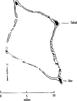
Marshall Islands Atoll InformationAur |
| Atoll (name) | Location | Number of Islets |
Land area (km2) | Lagoon area (km2) | Ratio land to lagoon area (km2) | |||||
|---|---|---|---|---|---|---|---|---|---|---|
| English | Marshallese | North | East | area | rank | area | rank | ratio | rank | |
| Aur | Aur | 8°12' | 171°06' | 42 | 5.62 | 15 | 239.78 | 14 | 2.34 | 14 |
 Aurh Ibbeson Ibbetson's Island (Gilbert 1788) Traversey I. (Kotzebue 1816)
Map of Aur Atoll (1897)
List of the Foreign property holdings during the German Colonial Period
Aurh Ibbeson Ibbetson's Island (Gilbert 1788) Traversey I. (Kotzebue 1816)
Map of Aur Atoll (1897)
List of the Foreign property holdings during the German Colonial Period
Historic Demographic Information for the Marshall Islands--Aur Atoll
Chronological listing of ships visiting the Marshall Islands until 1885 --Aur Atoll
Combat Chronology of the US Army Air Forces in operations against and from the Marshall Islands--Events regarding Aur Atoll
| select from the following... | ||||||
| |
||||||
|
Digital Micronesia-An
Electronic
Library & Archive
is provided free of charge
as an advertising-free
information service
for the world community. It is being maintained by Dirk
HR Spennemann, Associate
Professor in Cultural
Heritage Management, Institute of Land, Water and Society and School
of Environmental & Information Sciences, Charles
Sturt University,
Albury, Australia. The server
space and technical support are provided by Charles
Sturt University as part of its commitment
to regional engagement. Environmental
SciencesInformation
Sciences
|
||||||