Essays on the Marshallese Past

Erosion on Majuro Atoll


Majuro Atoll, situated at 7¹03'°7¹13' and 171¹02°171¹23'E. It is oriented ENE-WSW and covers a total lagoon area of 295km2 with a total land area of 9.17km2. In its greatest length (ENE-WSW) Majuro Atoll measures ~41.5km, while its greatest width (at 90¹ to the length) is 11km. Compared to the other atolls and islands of the Marshall Islands, Majuro Atoll ranks in the upper third. It is the 8th largest atoll in terms of landmass and the 13th largest in terms of lagoonal area.

The atoll can be split into a northwestern, windward side and a southeastern, leeward one. The northwestern part of the atoll is characterised by large, extended reef flats with only very few islands, save for the distinct Enyagin Group. This group, comprising Jelte and Rongrong, as well as a few other islets, is located at the very northwestern tip of the atoll and consists of two reasonably large islands (Jelte & Rongrong). Towards the east, the islands on the northern side become more numerous and are relatively closely spaced. There are located the three most populated islands (in 1992): Djarrit, Uliga and Delap.

The southern side of the atoll consisted until 1905 of a single continuous island reaching from Rairok to Laura. Effects of the typhoons of 1905 and 1918 have disrupted this continuous island, especially in its eastern part. In the southwest the island is still intact, largely only 200 to 300m wide, with the largest landmass of Majuro Atoll, Laura (Majuro Island) at its western end. Of the over 60 islands of the atoll, three islands belong to the large category (>0.5km2), ten to the medium category, and 51 to the small category (>=0.1km2). The following island are classified as of large size: Delap, Rairok and Laura/Ajeltake. Of medium size are: Enumanet, Anil, Enigu, Anenlibw, Jelte, Calalin, Irooj, Uliga, Rongrong and Djarrit.

The atoll has only one real deep water pass, navigatable for large canoes and all European vessels: the Calalin channel, located between Irooj and Calalin. In 1983 an artificial small boat channel was excavated at the western end of Bikielobo Island. While the common assumption is that only the main pass has been used for any larger vessels, both present and prehistoric, the German Naval vessel S.M.S. Habicht reportedly managed to enter the lagoon through a pass at the eastern end of the atolls, possibly the former entrance between Djarrit and Uliga. The western part of the lagoon is shallow with average depth of 20 to 40 metres and studded with a large number of coral heads, making navigation difficult. The eastern part, on the other hand, is deep, continuously over 40m and in parts well over 60 metres.

To understand erosion of coral atolls, we will need to have some understanding as to how the present atolls are formed. Atolls, such as Majuro, consist of an active coral reef flat, which has grown to its maximum level, and sand cays, which are formed by the erosion product of coral: sand and rubble. Since most corals cannot withstand exposure to air for a prolonged period of time without dying, the maximum level of coral growth is the level of the lowest sea-level, attained during low water at spring tides. Permanent wave action, as well as storms destroy some of the coral, tear it loose from its bases and grind it up, thus forming sand and rubble.

Sediment deposition

This sand and rubble is constantly moved around by the waves and deposited at those points where currents and waves meet (so-called node-points), creating an area of quiet water. The quieter the water, the finer the sediment will be which can be deposited there.

A look at a map of Majuro, shows that all large islands, such as Majuro (Laura), Jelte, Rongrong, Djarrit and Delap are on the leeward side of the island, are away from the dominant wind direction and away from the large ocean swell. In these quiet water conditions, over a period of time, a sufficient amount of coral sand could accumulate to create first inter-tidal sand-banks and then small islands, which gradually grew in size. Pioneering beach vegetation, created by seeds contained in sea bird excreta, such as creepers and vines helped to bind together the sands. Most of the island of Laura, for example, consists of fine sand several feet deep.

Apart from the islands on the leeward side, there are also islands on the windward side of the reef, but these islands consist mainly of coarser material, such as coral boulders and rubble. Visiting these islands on can see a zonation of material, with the largest rubble and boulders on the ocean side, some of them bigger than a human head, and the smallest on the lagoon side. Some islands even have small sand beaches at the lagoonside, close to the passes between the islands. At these points the current circulating in the lagoon and the water flowing through the pass into the lagoon at an incoming tide create a node point and a zone of quiet water, thus facilitating the deposition of sediment.

From the previous explanations, then, it should have become clear that any deposition of fine sediment, be it in the form of an inter-tidal sand bank or in the form of a vegetated sand cay is dependent on the direction and speed of currents and the overall patterns of wind and wave action. Therefore, a configuration of the sand cays on an atoll is always only a temporary one, prone to alterations as the current and wind/wave conditions change.

Map of Majuro Atoll showing major locations mentioned in the text.

Excluding climatic extremes, such as typhoons, natural alterations of the sand cay configuration are limited. Sand cays are sometimes known to migrate, that is they are eroded at one end and are gaining new sediment on the other end. This process is a very slow one and only perceivable over a life-time of a person.

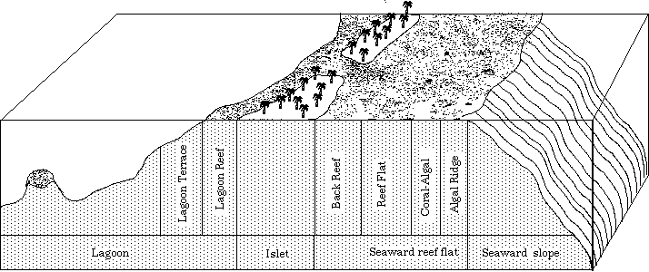
Typical zonation pattern of a windward atoll reef-flat.

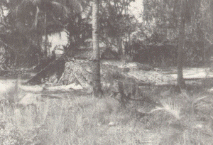
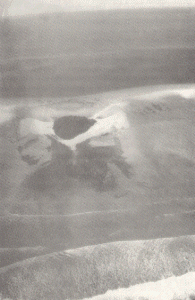
The natural environment of the Marshall Islands. Top: Aerial viewof the islands east of Rongrong from the south. The lagoon is to the left and the ocean to the right. Bottom: A traditional house has collapsed during a typhoon (Wootje Island)

Typhoons

In cases of extreme climatic events, such as typhoons, however, the appearance of sand cays can be altered dramatically in a very short time. To give an example: a particularly heavy typhoon hit the southern Marshall Islands in June 1905. A wave, "as high as coconut palms", according to eye witnesses who lived to tell the story, washed over Knox Atoll, washed away an entire island killing all inhabitants save for two in the process. The same happened in Mili. Of the entire sand cay, or island, only the barren reef flat remained.

But the course of events need not always be total destruction of an islet. The cyclone of 1918, which hit Majuro the hardest, especially affected the area from Long Island, that is from the U.S. Embassy, to Woja, that is close to Laura.

The natural environment of the Marshall Islands. Top: Aerial view of Wotje Island from the south. The lagoon is to the left and the ocean to the right. Bottom: A traditional house has collapsed during a typhoon (Wotje Island).

Here the wave action washing over the island eroded the shallow organic-rich topsoil and washed it lagoonwards. Where the islet was narrow, the debris was washed into the lagoon, thus widening the islet. Where the initial islet was wide, the debris was also pushed towards the lagoon, but, since the force of the wave action diminished as it washed over the islet, it was piled up as a wall of earth close to the lagoon. Driving to Laura, well past the airport, one can easily see this wall of soil on the lagoonside of the road. The whole water-washed area was then covered with a thick layer of coral boulders and rubble, scoured up on the reef-flats and dumped on the landØvery much to the distress of the present wato owners who cannot dig any hole without running into coral boulders of the size of a human head and bigger.

Seawalls and causeways

The most dramatic and most rapid change in the configuration of sand cays is caused by human interference, for example by the construction of seawalls and, more damagingly, causeways.

Sea-walls: Let us deal first with the seawalls. It needs to be understood that apart from the wave action battering the shore, there is also an inshore current, sometimes of little strength, which runs parallel to the shore. The oceanside of the three islands Djarrit, Uliga and Delap is densely occupied by housing often very close to the shore. Given wave action and currents the shoreline is prone to constant readjustments partially destroying backyards and even homes. Those who can afford such measures have erected seawalls to protect their property. While most seawalls follow the shoreline and provide armour for the existing shoreline, some individuals have used the seawall construction to reclaim some land. In these instances a rectangular area butts out onto the reefflat. This buttress, however, impedes the free flow of the current which become deflected and can cause erosion.

Causeways: While seawalls affect their immediate location, causeways affect entire islets. After a pass between to islets has been closed up, the in-shore currents running at the ocean side, and the currents running at the lagoon-side, no longer able to exchange water through the pass, are intesified and try to smooth off the edges of the new continuous island created by the causeway. Thus large-scale erosion is inevitable.

Maloelap and Mili: During World War II, the Japanese built military bases on several atolls and connected some of the islets there by causeways. Now, forty-five years on, we have excellent case studies of what happens to islets after a pass between to islets has been closed up.

Majuro: The same takes place at the causeways connecting the various islands of Majuro Atoll. At present, erosion not caused by seawalls is particularly prominent at the western end of Djarrit, where a large cemetery is gradually being washed away, at the western end of Uliga, where the compound and graveyard of Assumption is gradually diminished in size. In both cases the erosion is due to the closed former entrance to the lagoon forcing the currents to smooth of the edges and depositing the sand next to the causeway.

What happens to the eroded sand?

It needs to be added, that sediment which erodes from a sand cay or island at one point will only be lost if it falls off the reef edge on the ocean side. Given the wave patterns, this is a very rare occurrence indeed. In most cases sediment will be deposited in the form of an inter-tidal or sub-tidal sandbank close to the point where erosion takes place. Eventually it will end up at another wave-node pointØwhich may be the other end of the eroding island, or in a sediment trap. There is a small internal lagoon very close to the shore of Laura. This internal lagoon acts a sediment trap for the sand eroding at Laura point. According to Laura residents this internal lagoon is becoming shallower over time.

In the case of the causeways connecting the leeward side of Majuro, the sediment eroding from the western end of Djarrit, for example, will be deposited close to the causeway, thus widening the island bridge.

What can one do to avoid erosion caused by structures?

While natural erosion is a constantly reoccurring phenomenon which can only be stopped if the entire island is surrounded by a rip-rap, erosion caused by structures can be largely avoided. And it is simple: build appropriate seawalls and do not build any solid causeways. Rather than building a straightforward dam-type causeway, a causeway should be constructed which contains a series of culverts which permit the flow of water in and out of the lagoon and thus only minimally affect the configuration of currents and waterflows. In an ideal world one would construct a bridge, which would do the least damage, but unfortunately is also the most expensive solution.

However, incurring large scale erosion of prime land for the sake of a causeway is economically unsound, especially if a solution exists, the culverts, which combines both economical and environmental interests. In the case of Majuro, where the damage has already occurred, a detailed study is needed to determine on the strength and directions of forces active in the entire lagoonal system. In the long run then, measures could be proposed to partially or completely alleviate the existing problems.

A typical small islet on the windward reef platform seen at low tide. The islet is located on the lagoon side (top) of the reef. Sand spits are forming on both sides. Note the coral rubble ridge running from the island to the reefØs edge (bottom), and the well developed patch reef on the lagoon side of the island. (Wotje Atoll).


[Next Page]      [Back to Table of Contents]


Bibliographic citation for this document

Spennemann, Dirk H.R. (1998). Essays on the Marshallese Past Second edition. Albury:
URL: http://marshall.csu.edu.au/Marshalls/html/essays/es-1-2.html

CONTACT:
Dirk H.R. Spennemann, Institute of Land, Water and Society, Charles Sturt University, P.O.Box 789, Albury NSW 2640, Australia.
e-mail: dspennemann@csu.edu.au


select from the following...
FAQ
Environment
Politics
Economy
Health
Communications
Geography
History
World War II
Society
Culture
Art
Literature
Stamps


Digital Micronesia-An Electronic Library & Archive is provided free of charge as an advertising-free information service for the world community. It is being maintained by Dirk HR Spennemann, Associate Professor in Cultural Heritage Management, Institute of Land, Water and Society and School of Environmental & Information Sciences, Charles Sturt University, Albury, Australia. The server space and technical support are provided by Charles Sturt University as part of its commitment to regional engagement. Environmental SciencesInformation Sciences

© Dirk Spennemann 1999– 2005
Marshall Islands Kosrae CNMI Commonwealth of the Northern Mariana Islands Guam Wake Pohnpei FSM Federated States of Micronesia Yap Chuuk Marshall Islands politics public health environment culture WWII history literature XXX Cultural Heritage Management Micronesian Journal of the Humanities and Social Sciences CNMI German Colonial Sources Mariana Islands Historic Preservation Spennemann Dirk Spennemann Dirk HR Spennemann Murray Time Louis Becke Jane Downing Downing