|
|
Essays on the Marshallese Past
Archaeological Sites |
Archaeological research in the Marshall Islands is still scanty and the available data are still too incomplete to draw a detailed picture of the colonisation of the Marshall Islands. Both the date and the origin of the initial settlement of the Marshall Islands is still in doubt. Various routes of settlement have been assumed: one, favouring the settlement of the Marshall Islands from the south, starting with Fiji and then via the atolls of Tuvalu and Kiribati to the southern atolls of the Ralik or Ratak Chain. The other, less favoured point of view sees a human settlement coming from the west, that is from the Marianas via Pohnpei and/or Kosrae to the central or northern atolls of the Marshall Islands.
A number of radio carbon age determinations has been made, which show that human habitation in the Marshall Islands has been present since 500 BC on a number of atolls, among them definitely Majuro and Bikini. A solitary date from Bikini indicates that settlement may have been as early as 1500 BC.
The only remains of those times well before the memory of anyone are archaeological sites. These can be house sites, rubbish heaps (middens), gardening features or fishtraps. Sites such as these are spread throughout the Marshall Islands and are searched for and documented by the Historic Preservation Office. The information contained in some of these sites allows us to reconstruct the way of life over 2000 years ago.
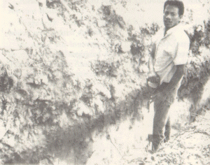
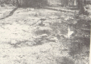
Destruction of the archaeological heritage caused by the excavation of banana planting trenches. Bottom: Archaeology unit inspects a trench which exposed two prehistoric gardening features (dark spots underneath the dark soil horizon).
By far the most abundant type of site in the Marshall Islands is the coral gravel scatter upon which the houses were built. These sites consist of irregularly shaped, though commonly roundish scatters of coral gravel of 20 to 60mm diameter. The gravel spread is anything between 0.1 and 0.3m thick and measures between 10 and 50m in diameter. In most cases seen the gravel spread does not form a visible elevation above the surrounding ground. Arteficial elevation does not appear to be common, if present at all.
Commonly the scatters show at one side an intermixture with bivalve and gastropod shells, predominantly Strombus luhuanus There is little difference between the gravel spreads dating to prehistoric times and those which are still being used. In early European times coral gravel spreads surrounded any Marshallese house. The reason for the coral gravel spread is simple. It creates an area which can be kept clean by pulling out the occasional intruding weed, and by avoiding sand and dirt from being carried into the house from the surrounding area. The coral gravel also visibly demarcates the area of the household used by the inhabitant of that household as their yard. Hence mats, clothes and the like, can be aired and dried without fear of dirtying them.
Coral gravel can be collected in the supra-tidal and inter-tidal zone of most oceanward beaches, where it forms a distinct zone, sorted to sediment size by the wave action. Then, as well as today, this material is brought in from the shore and spread around the houses. As the gravel is, over time and very gradually, trodden into the ground, more clean gravel is brought in and spread about. Thus, gradually, the coral gravel spreads increase in thickness.
Let us now look at the configuration of a household. Top: Schematic representation of a semi-traditional to modern Marshallese house hold. Bottom: Coral gravel spread with some coral boulders at the historic site of a Japanese trading station on Bouj, Ailinglaplap.
A semi-traditional to modern Marshallese house-hold (see figure below) consists of a living/sleeping house (2) with an associated water cistern (3), an outhouse (6), possibly a separate shower cubicle, a cooking house (4) with an open fireplace outside (5). All of this is situated on a coral gravel spread (1), which at one end merges with a small-scale rubbish and food refusal dump (7).
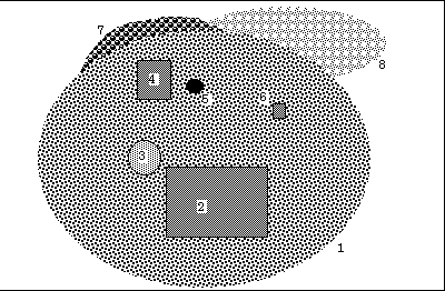
Top: Schematic representation of a semi-traditional to modern Marshallese house hold. Bottom: Coral grave spread with some coral boulders at the historic site of a Japanese trading station on Bouj, Ailinglaplap.
Coral-lined platforms are house sites, and sites of meeting houses, where the permiter of the coral gravel spread has been given a boundary of slabs of coral, set upright. While some of the coral lined platforms are very large, others are just large enough to surround a house itself.
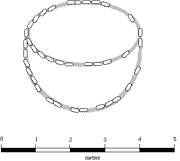
Naal Islet, Arno Atoll. Platform faced with coral slabs. The structure consists of an oval setting of small coral slabs set upright. Towards the lagoonside of the platform is another setting of coral slabs, forming a second oval. The internal oval measures 3.0 m in greatest length and 1.80m in greatest width. The individual slabs vary from 0.1 to 0.35m in length and 0.1 to 0.2m
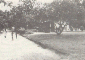
Road on Ebon Island, Ebon Atoll. Note the road boundary made of coral slabs and the coral gravel pavement to the right.
Very small coral-lined platforms, too small to be house platforms, could well be traditional or semi-traditional graves. Without excavation, this cannot be ascertained.
The German colonial administration forced many Marshallese the erect neat and tidy raods on their islands. These roads had also to be lined wirh coral slabs.
The limited land area available to the Marshallese forced them to think carefully about the burial of their dead. Unrestricted burial would have led, in a very shirt time, to the destruction of the scarce land suitable for gardening.
The practice espoused by the Marshallese, was to bury the commoners at sea. The corpses would be taken out to a special place, where the current runs away from the island. The bodies would be set adrift on rafts or old canoes to vanish into the ocean.
The chiefs and heads of lineages of both sexes, however, were buried. the burial sites are located just between the houses and the breadfruit forest. because of the land limitations, the dead of many generations would be buried all in the same location. After the arrival of the missionaries and the creation of churches as central places several centralised cemeteries, often located at the ocean shores were established.
Excavations of traditional cemeteries show a number of burials lying of top of each other or cutting into each other. The bodies, lying on their backs, are commonly oriented with their heads towards the east. Some burials show grave goods made of shell.
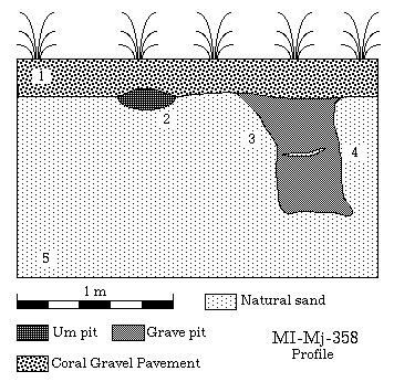
Drawing showing a grave pit exposed in the side wall of an excavation for a septic tank.
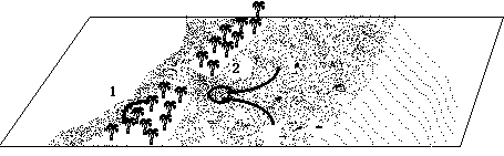
Prehistoric burials at Majuro Island (ËLauraÓ), Majuro Atoll, exposed in the course of construction. Note the close spacing and partial overlap of the burials
Prehistoric burials at Majuro Island (ËLauraÓ), Majuro Atoll, exposed in the course of construction. Close-ups. Note the bracelets and the beads.
Modern concrete grave markers resembling stepped pyramids. This design can be traced to the burial of Irooj laplap Kabua ("the Great", Ù 4 July 1910).
The prehistoric burials we know of, no longer have grave markers. Two excavated burials had a pile of roack directly over the body. At the time of the arrival of the Europeans the graves were marked by a pile of coral rocks and two paddles stuck into the ground. Following European examples, the graves since the turn of the century are marked by rectangular rows of coral boulders bottles, or concrete. Beginning with the grave of Irooj laplap Kabua ("the Great", Ù 4 July 1910), large concrete structures were built, resembling the sarcophagi in medieval churches in Europe. Others resemble small stepped pyramids.
The fishtraps or stone-walled fish weirs operate on the principle of fish retention with falling tide. While the fish can roam freely at high tide on the reef flat, their movement is restricted once the water-level falls below that of the stone walls. The fish will then swim with the receding water and will, therefore, be "dragged" into the round retention basin at the end of the V. In the case of the semi-circular traps, the highest point is at the seaward side and the fish will not be able to cross over, thus gradually being retained in a small basin. The main principle of the fishtraps is to build the wall that high that fish can swim unhindered at high tide, but that the movement is impeded at that point of the tidal cycle when the fish begin to move back to the reefˆs edge. In general, fishtraps are operated only at the time of the spring tides, that is once every lunar cycle. At best, the traps have a utilisation of 3 out of 28 days and the effort involved in rebuilding them every time they are to be used is considerable.
Fishtraps 1 - semi-circular retention basin on the lagoonal shore, 2 - V-shaped fishtrap on the seaward reef flat.
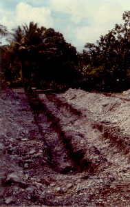
In order to be able to grow wetland taro (Cyrtosperma sp.) on the coral atolls, it is necessary to lower the ground level to such an extent that the plants can root in the groundwater lens. Since the elevation of the groundwater lens fluctuates with the level of the tide, care needs to be taken not to dig too deep a hole in order not to drown the roots. This reduction of ground elevation was made in the middle of the larger islands, where a permanent ground water lens existed. Large pits were excavated and the quarried sand was used to heightened the surrounding terrain. In a well developed area there was little land left between the taro patches and the land between was used as tracks. These taro planting pits measure in size anywhere from 5x10m to 25x80m. Smaller pits are more common. The shape of the pit is usually rectangular or subrectangular, although L-shaped and C-shaped pits are not rare.
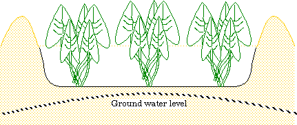
Cross-section through a typical taro pit
| select from the following... | ||||||
| |
||||||
|
Digital Micronesia-An
Electronic
Library & Archive
is provided free of charge
as an advertising-free
information service
for the world community. It is being maintained by Dirk
HR Spennemann, Associate
Professor in Cultural
Heritage Management, Institute of Land, Water and Society and School
of Environmental & Information Sciences, Charles
Sturt University,
Albury, Australia. The server
space and technical support are provided by Charles
Sturt University as part of its commitment
to regional engagement. Environmental
SciencesInformation
Sciences
|
||||||