Essays on the Marshallese Past
The impact of an unnamed typhoon in 1918
on Majuro Atoll

|
It is the fundamental belief of the Historic Preservation Office that the information
contained in the stories, and the skills developed by Marshallese of old, are still very
much of value for a modern Marshallese society. The recent events of the tropical storm and
later typhoon "Zelda" in 1991, led to the following reflection on past
experiences.
End of November 1991 the Marshall Islands once more experienced the
unpleasant effects of a tropical storm. However, despite the damage incurred, some $10
million estimated, and despite 3000 people made homeless on Ebeye, the impact of tropical
depression/typhoon "Zelda", was only moderate. For example large wide spread
flooding did not occur. Most people on Majuro still remember the destruction
wreaked by the high tides of 1979, making some 4000 people homeless. These tides occurred
without any accompanying storm winds. At the time "Zelda" hit most of the
atolls it was only a tropical depression.
History, recent history at that, shows what could have happened if a full-blown
typhoon would have struck the atolls. The last two severe typhoons to hit the southern
Marshall Islands
occurred in 1905 and 1918.
On June 30th, 1905 a typhoon struck Arno, Mile,
Nadikdik
(Knox) and Jaluit Atolls.
Three gigantic waves, one larger than the other hit Mile Atoll, washed over
the islands.
According to eye-witnesses, the third, and largest of these, was as high as the tops of the
coconut trees. Even if we take exaggeration into account and allow for the crest of the
waves to consist of wind-driven foam, a wave height of some 8 to 10m can be estimated. On
Mile
a small island was completely washed away, and some other narrow islands
were breached in many locations. Neighbouring Nadikdik Atoll was completely
washed over, several inhabited islands reduced to the bare reef platform and the human
population of that atoll completly extinguished.
Arno was hit next with waves breaching some islands and washing away
3 quarters of the narrow southeastern strip of land. When the typhoon passed over
Jaluit
it was low tide and so the impact was much less than on
Mile
or Nadikdik. Nonetheless flooding occurred, several
ships sunk in the lagoon and the entire European settlement was completely flattened. Over
200 people lost their lives on that day on the affected atolls, most of them on
Nadikdik
and Mile. The people on Arno had sufficient warning
to flee across the lagoon to the larger Western Islands and seek shelter
there, resulting in a few casualties but no loss of lives.
Following the destruction of all food stocks and fruit on the trees, another 90 people died
in the following months due to starvation.
The lagoon of Mile, and to a lesser extent of Jaluit was
reported to be choc-a-bloc full of floating debris: trees, bushes, houses, broken canoes,
wooden utensils and corpses.
The concentration of drift material in the waters of the Marshalls during July and August
1905 was so high that it constituted a serious shipping hazard, making the anyway limited
relief operations not any easier. The flooding by salt water caused die back of several
fruit trees as well as the contamination of the freshwater lens. During this
event in 1905, the waves breached the narrow strip of land on two locations on the
southeastern coast
, somewhere between Delap and
Rairok
. Majuro lost a land area of a total of 3 miles length.
In 1918 a very severe typhoon struck Majuro and
Arno Atolls
. If affected most severely the islands between
Delap
and Woja. On November 8, 1918, a tidal wave washed
across the southern part of Majuro flooding an area over 20 miles in length.
The wave impact was not sufficient to reduce the island to the bare reef platform, but
breached the narrow island in many locations in the southeastern corner of the
atoll. The islands devastated by this typhoon range from the pub end of
Delap
to Woja. Until 1905 there had been a continuous land
connection between Delap and Majuro Island (Laura).
The typhoon of 1905 breached this in two locations, and the 1918 event smashed it in
numerous locations between Delap and Ajeltake.
The most serious breaches were along the southeastern corner, between Delap
and Rairok, leaving only little bits of land behind, such as
Utwe
or Enirak, now all rejoined by a causeway.
In the southwestern areas the wave power was insufficient to breach the island, but
strong enough to bombard it with coral boulders torn loose from the reefˆs edge and to remove
all topsoil, as little as there was. Trees, small vegetation and house sites were washed into
the lagoon.
On the other islands of Majuro damage seems to have been restricted
to wind damage of houses and trees. The typhoon of 1918 was devastating for
Majuro Atoll
. All the churches were destroyed. All thatch stores and branches
were destroyed as were many or most of the thatch houses. The Missionary Herald for 1919
reported on the destruction:
"Mejuro looks like a wilderness and the food prospect for the
Marshalls
looks not too cheerful. About 129 died in the storm, a small
fraction, perhaps, from the immediate effects of the typhoon, many deaths being caused by
the waves.
The islands have so little elevation above the sea that the tidal wave, which usually
follows the wind, does much injury to life and land. The wave did not go over mission
property, either at Mejuro (Laura) or at Roritori (Rongrong),
but the wind carried the salt water in sufficient quantities to make everything pretty salt.
"
There seems to have been little forewarning and accoring to Japanese casualty figures
all told over 200 people drowned on that day on Majuro alone.
The after-effects on the vegetation were also severe, for example it took over 15
years for the copra production on this stretch of Majuro to
recover. On neighbouring Arno Atoll the wave-damage was limited, but almost
every small and medium-sized breadfruit tree was blown over causing serious food shortages.
The force of the waves can be seen on Ajeltake, where the entire
surface is covered with coral rubble up to the size of 0.4m3 (3-5 cubic feet).
The surface shows very little evidence of topsoil development, indicating a substantial
deposition of storm sediments.
In parts of Rairok and Ajeltake, transects and trenches
perpendicular to the long axis of the island show a deposition of coarse and cobbly coral
material on the ocean side, gradually thinning out, with a deposition of fine material on
the lagoon side. In instances these depositions overlie an old A-horizon, clearly
indicating a unique sedimentation event.
In parts of Ajeltake and Woja a distinct soilwall can be
seen in the lagoon side of the island, which - judging from the erosion features on the
lagoonal shore - seems to consists solely of fine grained material, while the land surface,
almost to the foot of this soil wall, is covered with coral boulders and rubble. It seems as
if the entire topsoil was scoured up during the typhoon and was washed lagoonwards. There,
where the island was narrow, the soil was washed into the lagoon itself, thus widening the
island; however, there, where the island was too wide, and where the wave energy was
insufficient, the topsoil was deposited as a soil wall on the lagoonal shore.
The 1918 typhoon led to a response by the Japanese government. A patrol boat was
dispatched to assess the damage incurred, to supply emergency food supplies free of charge
to people in need and to initate other relief measures as required. It appears that the
Japanese Emperor himself contributed some funds from the Palace allocation
(Japanese Government 1922). However, the coconut plantations in the areas were not fully in
production again until the late 1920s.
After the typhoon 1918, re-planting of the destroyed coconut plantations began
apparently with Japanese Government (Imperial) aid funding. In commemoration of the aid
given by the Emperor, the Japanese erected a monument in Laura. The
inscription reads:
The Japanese Typhoon Monument at Laura, Majuro Atoll.
Monument to the Imperial Graciousness
On November 8, 1918, a typhoon struck the Marshall Islands, and, especially here at
Majuro, a tidal wave, accompanied by heavy seas, cast people and their possessions adrift.
There were probably about two hundred casualties. Such disastrous damage was hitherto
unparalled in these islands. When the news reached the Emperor, His Majesty was deeply
concerned, and it was on January 14, 1919, that Imperial private funds were donated. The
magnificent impartial favours of Imperial benevolence extend from afar to the South Seas;
however, a response telling of a deeply grateful emotion will not be desired. The Island
people historically live in peace, and the teaching of the way of loyalty to the Emperor
and of filial piety will well suffice forever. In accordance with the feeling of gratitude
for these Imperial favours, this text on the aid to this land is carved on stone to be
transmitted to future generations.
November 14, 1919
Respectfully composed by Nagata Tenjiro, Rear-Admiral of the Navy,
Senior Grade Fifth Rank, Second Order of Merit, Third Class; Acting Commander, South Seas
Islands Defense Forces.
Respectfully inscribed by Fujino Seiki, President, Imperial
Chrysanthemum Garden Institute.
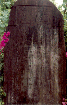
The Japanese Typhoon Monument at Laura, Majuro Atoll.
As typhoon "Zelda", "Axel" (both 1991), "Gay"
(1992) and many other tropical storms and typhoons before have shown, not all typhoons need
to be that destructive as those of 1905 and 1918, but it may be too costly to underestimate
the potential of a re-occurence. One of the potential impacts of Global Climate Change is an
increase of the sea surface temperature which in turn is likely to increase typhoon
frequency and intensity. The variations in typhoon occurrence as a result of the cyclic
ocean warming caused by the El Ni¾o effect are ample proof of the effects
of limited temperature variations. Thus, a repeat of the 1918 disaster may just be round
the corner-or it may take a long time to come.
The past has much advice to offer for future development. Many skills were developed
over the more than 2000 years the Marshallese settled the atolls now named the
Marshall Islands
. In our case, previous experience, in the literal sense of
the word, taught the Marshallese where to settle, which islands on an atoll to chose.
Traditionally the windward islets were only used for temporary settlement or saw a very
small scattered population residing there, while the larger islands on the leeward side of
an atoll were inhabited. Placing the population concentration on these not only ensured
protection from extreme climatic events such as typhoons and tidal waves, but also ensured
a reliable ground water and food supply for the daily life. While in the mean time
technological development has moved ahead at a dramatic rate, people are still at the whim
of unharnessed nature's ire: the typhoon experiences of the past are still valid today.
The post-World War II settlements on Ebeye and the D-U-D area on Majuro Atoll have
departed from that traditional wisdom, both are erected on the exposed windward side of
the atolls, and both islands had to pay a price during typhoon Zelda. Let us hope that
the price to ignore the lessons of the past will one day not be too high a price to pay.
Bibliographic citation for this document
Spennemann, Dirk H.R. (1998). Essays on the Marshallese Past Second edition.
Albury:
URL: http://marshall.csu.edu.au/Marshalls/html/essays/es-eh-1.html
CONTACT:
Dirk H.R. Spennemann,
Institute of Land, Water and Society,
Charles Sturt University, P.O.Box 789,
Albury NSW 2640, Australia.
e-mail: dspennemann@csu.edu.au
| select from the following... |
|
|
|
|
|
|
|
|
|
|
|
|
|
|
|
| |
|
|