
|
|
Essays on the Marshallese Past
Historical Sites on
|
Wotje (population ~650) is the largest island on Wotje Atoll, some 60 flight minutes north of
We do not know when the first people can to settle on Wotje Atoll, but a date around the middle of the first millenium B.C. can safely be assumed.
At the time of contact with Europeans Wotje was inhabited by over 350 people with the population concentrated at the eastern end of the atoll. Wotje first attained European fame during the beginning of the 19th century, when the Russian Expedition under command of
Purchasing the Marshalls from
After the capitulation of the German Empire in 1918, the newly formed League of Nations gave all former German possessions north of the Equator for administration to the Japanese Empire. The Japanese established a centralised district administration in Jaluit, with the internal affairs of Wotje left to be handled by a local atoll authorities, after the radio station had been removed in 1922. The Japanese established a school on the island, which served for the atolls of the central and northern Ratak Chain.
In the late 1930s Japan began to fortify its Marshallese possessions contrary to the Convenant of the League of Nations. These fortifications were centered on
In order to create a suitable defense system at its perimeter, the Japanese navy decided to develop some of the atolls of the Marshall Islands into bases for seaplanes, for naval surface units submarines, and, with the advent of long-range land-based bombers, as airfields.
Wotje was to become the major sea-plane of the Marshall Islands. The development of the Wotje base began in late 1939, when a battalion of Japanese prisoners was drafted for the construction of the airfield. The Japanese constructed an airfield with two runways (34500 and 5000 feet), two hangars and a service apron. In addition, a seaplane ramp and a major pier were built. By end of 1943 there were also several hundred buildings, mainly of wooden construction, and several repair shops.
The island was garrisoned by 2100 Navy and 420 Army Personnel, under the command of
The perimeter of the island, especially the ocean side, bristled with guns, which were a mixture of British and Japanese manufacture: six 150mm (6") coastal defense guns, and six 127 mm (5") twin-mount dual purpose guns. The Japanese Army had brought an additional five 150mm (6") field artillery guns. Both services had an assortment of smaller guns, such as six 37 mm anti tank guns and about 90 heavy and light anti-aircraft guns, and heavy machine guns.
In addition, two 120 mm (4 ") ship guns were emplaced as coastal defense guns. These had come from the Goyotsu Maru, a Japanese supply ship which was beached in 1943 off Kimejo Island, south of Wotje Island, after having been attacked by U.S. aircraft. The remains of the vessel can still be seen.
There was one radar set (range 50 miles) on island, giving the air wing some 10 minutes warning. During the war two squadrons of planes were temporarily stationed here, namely torpedo bombers ("Kate", "Val") and patrol bombers ("Nell", "Betty"). At the beginning of the war the plane contingent of the 801st squadron, consisted of between 6 and 12 Kawanishi H6K flying boats ("Mavis"), which were later replaced by the larger H8K flying boats ("Emily").
Wotje had gained fame during the war as from here the air raids on
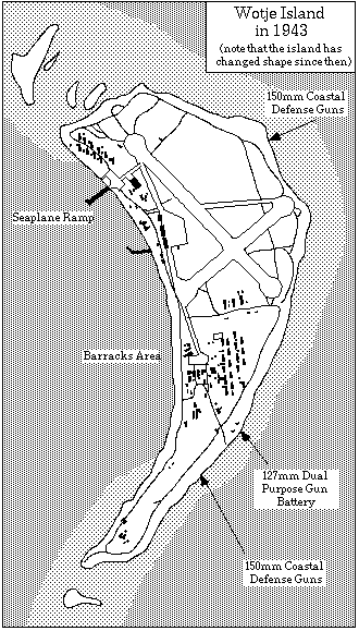
Map of the Japanese installations on Wotje Island.
Between mid-1943 and Aug. 1945, US aircraft dropped 3500t bombs and US ships shot 1000t shells onto Wotje. While the first attacks were carrier-based and irregular, daily attacks were started after Majuro and Kwajalein had fallen to the US. At the same time, all supply lines to Wotje were cut off, and the Japanese garrison was left to starve. Of the originally 3300 strong Japanese garrison only 1200 (37%) survived. Casualties occurred from air raids, diseases, accidents, and suicides, but mainly from starvation.
Wotje Island, as you see it today, is the result of three dramatic alterations caused by people: the natural primary forest of the island had been cleared by the first Marshallese settlers and replaced, where possible, by breadfruit trees and taro pits to provide food. During the German times the breadfruit trees were largely replaced by coconut to produce copra. The final transformation came in preparation for the base development, when all trees in the center were cut down to allow for runways, taxiways, roads, barracks areas and the like. Today these areas are largely overgrown with scrub and low but very dense bush.
Walking off the grass-covered runway you may notice the concrete guttering which circles the entire runway and which served as the main rainwater catchment for the Japanese garrison. Going towards the lagoonal shore you will encounter a large area paved with concret--the service apron of the base. Here all landbased planes, as well as the sea-planes when pulled ashore, would be serviced. War damage can easily be recognised by all the trees growing on the apron--they grow in bombcraters.
Around this apron are found all the main buildings of the base: the air operations building, two hangars, the seaplane command building, the radio building, and a small generator station. Next to the church is a Japanese 120mm gun, originally from the
Going towards the south you will encounter a set of giant fuel tanks, which once contained aviation fuel. the main power station of the island, which has been destroyed by a direct hit, and close to it the torpedo plant. In the giant building, which consisted of a framework of steel girders and which was covered with a wood and glass roof, torpedoes would be assembled, filled with compressed air and furnished with a warhead. The torpedo racks, as well as the compressors for the air can be easily recognised.
Further to the south you will go past the foundations of several barracks buildings and will reach a 127mm dual purpose gun position. There are three gun emplacements, one of which never contained a gun. If you explore the large soil hump just inland of the empty emplacement, you will find the bombed out remains of the command post for the entire gun battery.
![]()
| select from the following... | ||||||
| |
||||||
|
Digital Micronesia-An
Electronic
Library & Archive
is provided free of charge
as an advertising-free
information service
for the world community. It is being maintained by Dirk
HR Spennemann, Associate
Professor in Cultural
Heritage Management, Institute of Land, Water and Society and School
of Environmental & Information Sciences, Charles
Sturt University,
Albury, Australia. The server
space and technical support are provided by Charles
Sturt University as part of its commitment
to regional engagement. Environmental
SciencesInformation
Sciences
|
||||||