
|
|

|
British Naval Heritage in Micronesia:
|
Over time, Japan began restricting the movements of foreigners in the area, which created suspicions of untoward activities violating the covenant of the mandate. In the 1930s the world watched with ever increasing unease the real and the perceived developments in the Mandated Territory of the Pacific Islands (Micronesia), especially following Japan's refusal to sign the continuation of the Washington Naval Limitation Treaty on Naval Tonnage in 1935 and their departure from the League of Nations a year later (Peattie 1988). Japan was feared to develop strategic strongholds and the military infrastructure on various--if not most of the--islands, a fear fueled by the secrecy with which she shrouded the mandated territory.
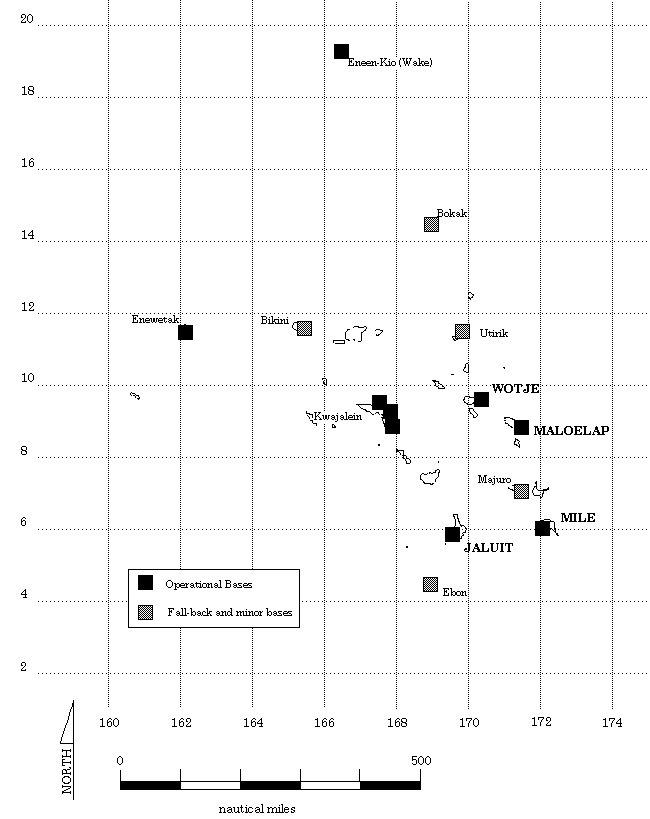
Following the attack on Pearl Harbor, Japan used bases in the islands for a swift and wide-ranging attack on Allied shipping and insular possessions such as Guam, Wake I. and Kiribati (then the Gilbert Islands). Substantial development occurred in Palau, Chuuk, as well as on a host of other locations. The eastern perimeter was also heavily fortified with naval and air bases centered on Kwajalein, Maloelap and Wotje. Mile, Jaluit and Eneen-kio (Wake I.) also had bases and heavy coastal defense installations (Figure 1). While most of the US bases as well as those in the Japanese-conquered areas were of a temporary nature only, the Japanese bases in Micronesia had been built as permanent installations with elaborate concrete structure and a well designed infrastructure.
Most, if not all, of the Japanese military installations had been destroyed from a military point of view by the often daily bombing runs, but much of the substance of the buildings and gun emplacements are still around. From the perspective of Historic Preservation these sites are damaged, as far as their pre-World War II appearance is concerned, but that damage forms part of the historical context in which these sites need to be interpreted.
In modern terms this means that these islands abound with war remains, ranging from runways, taxiways, hangars, aircraft revetments and other parts of the air installations to docks, piers, and sea-plane ramps. There are gun positions for coastal defense guns, anti-aircraft batteries and dual purpose guns; personnel shelters, ammunition magazines, bunkers, blockhouses, command centers, remains of barracks buildings, mess halls and the like. The infrastructure consisted, among other things, of water storage tanks and collection systems, repair shops, power stations, radio stations, hospital facilities, laundry units and sewerage facilities. Even after an abundance of war material from both Allies and Japanese had been removed after the cessation of hostilities, the artefactual inventory is very impressive: it includes shipwrecks, airplane wrecks, tanks, vehicles, railroad engines and rolling stock, as well as searchlights, light and heavy guns, and an abundance of unexploded ammunition. Aspects of after-hours life are also represented in the form of sake and beer bottles and the like. In short, the remains of these bases comprise all aspects of military life and present them in a complete manner and as such represent time capsules. Battlefields were left behind littered with burned-out tanks and vehicles, scattered small arms and ammunition.
The guns of the three major bases have been surveyed by the Republic of the Marshall Islands Historic Preservation Office: Mile, Taroa and Wotje. The description of one of them, Wotje (figure 2), may suffice to provide an overview over the nature of such bases.
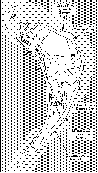
Figure 2. Map of the Japanese installations on Wotje Island, Wotje Atoll
The garrison of Wotje, at peak strength in December 1943, consisted on 3,298
men, 2,103 Navy and 429 Army personnel, and 766 civilian (and Korean)
construction workers under the command of Captain (later Rear-Admiral) Nobukazu
Yoshimi, of the Imperial Japanese Navy. Of these only 1244 or 37.72% survived
until surrender in August 1944. Between mid-1943 and Aug. 1945, US aircraft
dropped 3500t bombs and US ships shot 1000t shells onto Wotje. While the first
attacks were carrier-based and irregular, daily attacks were started after
Majuro and Kwajalein had fallen to the US. At the same time, all supply lines
to Wotje were cut off, and the Japanese garrison was left to starve. Of the
originally 3300 strong Japanese garrison only 1200 (37%) survived. Casualties
occurred from air raids, diseases, accidents, and suicides, but mainly from
starvation.
At the beginning of WW I 1914 Japan took over the Marshalls and developed a radio station on Wotje Atoll. After the capitulation of the German Empire in 1918, the newly formed League of Nations gave all former German possessions north of the Equator for administration to the Japanese Empire. The Japanese established a centralised district administration in Jaluit, with the internal affairs of Wotje left to be handled by a local atoll authorities, after the radio station had been removed in 1922. The Japanese established a school on the island, which served for the atolls of the central and northern Ratak Chain.
The development of Wotje Atoll was part in the grand strategic scheme. During the 1930s, Wotje had been used as a location for naval maneuvres and sea-plane trials. In order to create a suitable defense system at its perimeter, the Japanese navy decided to develop some of the atolls of the Marshall Islands into bases for seaplanes, for naval surface units submarines, and, with the advent of long-range land-based bombers, as airfields. Wotje was to become the major sea-plane of the Marshall Islands. The development of the Wotje base began in late 1939, when a battalion of Japanese prisoners was drafted for the construction of the airfield. The Japanese constructed an airfield with two runways (34500 and 5000 feet), two hangars and a service apron. In addition, a seaplane ramp and a major pier were built. By end of 1943 there were also several hundred buildings, mainly of wooden construction, and several repair shops. Wotje had gained fame during the war as from here the air raids on Eneen-Kio (Wake Island) were flown. In addition, the only bombing of Hawaii after Pearl Harbor was executed by seaplanes starting from Wotje. Of four the by-passed atolls, Wotje took the heaviest pounding. Of the total 15288.7 of bombs and naval shells delivered against targets on these bases, Wotje received 4508.70t or 29.50%.
The perimeter of the island, especially the ocean side, bristled with guns, which were a mixture of British and Japanese manufacture: six 150mm (6") coastal defense guns, and six 127 mm (5") twin-mount dual purpose guns. The Japanese Army had brought an additional five 150mm (6") field artillery guns. Both services had an assortment of smaller guns, such as six 37 mm anti tank guns and about 90 heavy and light anti-aircraft guns, and heavy machine guns. In addition, two 120 mm (4 ") ship guns were emplaced as coastal defense guns. These had come from the Goyotsu Maru, a Japanese supply ship which was beached in 1943 off Kimejo Island, south of Wotje Island, after having been attacked by U.S. aircraft. The remains of the vessel can still be seen. There was one radar set (range 50 miles) on island, giving the air wing some 10 minutes warning. During the war two squadrons of planes were temporarily stationed here, namely torpedo bombers (`Kate", "Val") and patrol bombers ("Nell", "Betty"). At the beginning of the war the plane contingent of the 801st squadron, consisted of between 6 and 12 Kawanishi H6K flying boats ("Mavis"), which were later replaced by the larger H8K flying boats ("Emily').
![]()
| select from the following... | ||||||
| |
||||||
|
Digital Micronesia-An
Electronic
Library & Archive
is provided free of charge
as an advertising-free
information service
for the world community. It is being maintained by Dirk
HR Spennemann, Associate
Professor in Cultural
Heritage Management, Institute of Land, Water and Society and School
of Environmental & Information Sciences, Charles
Sturt University,
Albury, Australia. The server
space and technical support are provided by Charles
Sturt University as part of its commitment
to regional engagement. Environmental
SciencesInformation
Sciences
|
||||||