
|
|
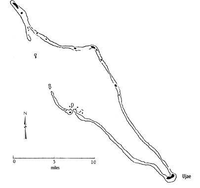
Marshall Islands Atoll InformationUjae Atoll |
| Atoll (name) | Location | Number of Islets |
Land area (km2) | Lagoon area (km2) | Ratio land to lagoon area (km2) | |||||
|---|---|---|---|---|---|---|---|---|---|---|
| English | Marshallese | North | East | area | rank | area | rank | ratio | rank | |
| Ujae | Ujae | 9°00' | 165°45' | 14 | 1.86 | 22 | 185.94 | 16 | 1.00 | 24 |
 Catherine I. (Moore 1804) Katherine I. (Moore 1804) Lydia (Moore 1804) Margaret (Moore 1804) Serpent (Hammond 1853) Udjae Ujamilai (Kotzebue 1825)
View a 1881 map of Ujae Atoll
Map of Ujae Atoll (1897)
List of the Foreign property holdings during the German Colonial Period
Catherine I. (Moore 1804) Katherine I. (Moore 1804) Lydia (Moore 1804) Margaret (Moore 1804) Serpent (Hammond 1853) Udjae Ujamilai (Kotzebue 1825)
View a 1881 map of Ujae Atoll
Map of Ujae Atoll (1897)
List of the Foreign property holdings during the German Colonial Period
Historic Demographic Information for the Marshall Islands--Ujae Atoll
Chronological listing of ships visiting the Marshall Islands until 1885 --Ujae Atoll
| select from the following... | ||||||
| |
||||||
|
Digital Micronesia-An
Electronic
Library & Archive
is provided free of charge
as an advertising-free
information service
for the world community. It is being maintained by Dirk
HR Spennemann, Associate
Professor in Cultural
Heritage Management, Institute of Land, Water and Society and School
of Environmental & Information Sciences, Charles
Sturt University,
Albury, Australia. The server
space and technical support are provided by Charles
Sturt University as part of its commitment
to regional engagement. Environmental
SciencesInformation
Sciences
|
||||||