|
|
The Sea - The Marshallese Worldby Dirk H.R. Spennemann |
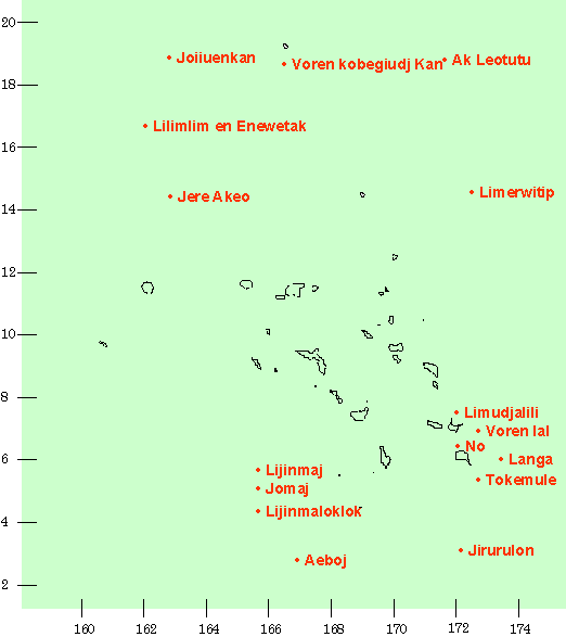
| Name | Translation | Type of sea mark | Modern name on charts | approx. location |
| Aeboj (Aeböj Ed) | The fresh waterwell | reef | southwest of Ebon | |
| Ak Leotutu | east of Wake | |||
| Jere Akeo (Jede Ak Eo) | west of Bokak & northwest of Bikini | |||
| Jirurulon | southeast of Ebon & south of Mile | |||
| Joiiuenkan (Iurin Torrlön Kan) | The flight of the great frigate bird | sea mark | west of Wake & northwest of Bikini | |
| Jomaj | east of Jaluit/Namorik | |||
| Langa | reef | Keats Bank | 90 nm east of Mile | |
| Lijinmaj | east of Jaluit/Namorik | |||
| Lijinmaloklok (Lijinuanoknok) | wave node | west of Ebon/Namorik | ||
| Limerwitip (Limädiwitüb) | sea mark | east of Bokak, also leeward of Mejit | ||
| Limlim en Enewetak (Liuliuin Enewetak) | sea mark | two days north of Enewetok [7] | ||
| Limudjalili (Limjujanülü) | reef | north of Arno | ||
| reef | Neptuns Bank? | [33 nm] east of Arno [8] | ||
| Lukwejeja | Middle of nowhere | reef | near Neptuns Bank | east of Arno |
| Mermerkan Ruo (nöruör Kad Ruo) | The two foams | sea marks | south of Mile | |
| No | reef? | between Arno & Mile [9] | ||
| Tokomule | southeast of Mile | |||
| Voren kobeguidj kan (Wödenköpakut Kad) | reefs | three days north of Bikini | ||
| Voren lal (Wüdelan) | Pound the bottom | reef | Neptuns Bank? | east of Arno |
The only major geographical and possibly geopolitical differentiation known to Marshallese was between the two chains of atolls, the people addressing each other as Ri-Ratak or Ri-Ralik.[10]
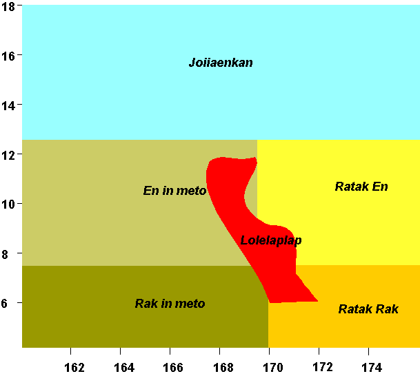
For the Marshallese, the atolls of the northern Ratak Chain, north Majuro and Arno, and including Bokak and Eneen-Kio was Ratak En. The sea north of Bokak and Bikini was called Joiiaenkan.[11] The territory around Majuro, Arno, Mile and Nadikdik (Knox Atoll) was called Ratak Rak. The territory around Ebon, Namorik, Jaluit, Kili and half of Ailinglaplap is named Rak in meto, while the general name for the northern rest if the Ratak Chain is En in meto.
The sea between the Ralik and Ratak Chains is called Lolelaplap (fig. 3.1).[12] The sea marks to which has been alluded above , are plotted in fig. 3.2, as far as they can be placed on map.
The Marshallese koine, the world in which they sailed, ranged from at least Kosrae [13] and Ponape, possibly Yap in the west,[14] to central Kiribati and Banaba (Ocean I.) in the south, Eneen-Kio in the north and Johnston and probably Hawaii in the east.[15]
The world they knew about, however, was considerably larger, as they had been in contact with the people they had visited, as well as with the people who had visited them either intentionally or accidentally, namely Carolineans [16] and i-Kiribati. [17] In addition, their own accidental dispersals carried the Marshallese far afield. [18]
![]()
Bibliographic citation for this document
Spennemann, Dirk H.R. (2000) The Sea - The Marshallese World, Albury. URL: http:/marshall.csu.edu.au/Marshalls/html/culture/SeaNavigation.html
![]()
CONTACT:
Dirk H.R. Spennemann,
Institute of Land, Water and Society,
Charles Sturt University, P.O.Box 789,
Albury NSW 2640, Australia.
e-mail: dspennemann@csu.edu.au
![]()