
|
|
Essays on the Marshallese Past
Traditional Marshallese Stickchart Navigation |
Marshallese have always been noted for their navigational skill and in the past only a certain few people, either men or women, were taught the secrets of sailing and navigation. The stick charts were constructed as instructional aids for teaching to preserve knowledge. They were not taken on voyages, for all knowledge was memorised. The charts depict natural phenomena and interpret the wave and current patterns that strike the islands. Long before modern day navigational instruments were brought to the Marshallese, they travelled the ocean, maintained courses and determined positions of islands by the use of wave patterns that are depicted in the stick charts.
Very few people today understand these charts, although many people know how to make them. In fact some types of stick charts of today, particularly the two common types of the Wave Navigation
In the Pacific, navigation was mainly by the position of the stars and the sun and moon (celestial navigation), and secondly by waves. The
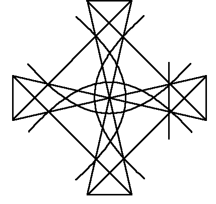
Figure 1. A teaching chart (
To teach the recognition of the wave patterns at sea, young apprentices underwent practical training, and all navigators had stick charts on which the orientation and the sequence of the currents and wave patterns was marked. These stick charts were never taken out to sea, as our modern charts are, but were used a memory aids to rehearse waver pattern to be encountered, to learn the voyage plan by rote before actually setting out to sea.
While modern charts are universal and can be used to navigate from any location on the chart to any other location on or even off the chart, the Marshallese stick charts are predominantly uni-directional. They explain how to get from a given starting point to one or more target points. As the wave patterns for the return voyage are different from the patterns of the initial voyage, the charts of little use to navigate back, let alone to navigate between other islands marked on the stick chart. In the light of this, then, it is not surprising that the charts were not taken along on the voyage. The necessary knowledge would have been memorised anyway, and the chart would have been useless at any location other than the starting point. There are two types of stick charts. Let us first look at the underlying principle of wave pattern navigation, and then discuss in detail one type of stick chart, the
In the middle of the ocean, waves are set into motion and moved by the wind. These wind-generated waves, the ocean swell, have a long interval and travel in a straight line over great distances. They can change in direction, if the wind direction changes over a prolonged period of time. Changes in wind direction, which occur only for a short time, create waves which may run at angles to the swell.
In addition, there are ocean currents. While the waves travel horizontally, they move water masses mainly in a vertical fashion, and only very little in a horizontal manner. Objects drifting on the water are not displaced by waves, but by the wind generating the latter. Currents, however, move water masses in a horizontal manner, and displace object floating in or on the water. Thus currents can easily set a canoe of its intended course.
In the area of the
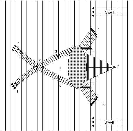
Figure 2. Principles of Wave Pattern Navigation (for explanation see text)
Wave pattern navigation is based on the principle of reflection, deflection and refraction of waves. To understand wave pattern navigation, let us first consider a single, isolated island or atoll. If waves hit a stable object, such as an island, some waves are reflected, that is mirrored back into the direction from which they came (figure 2a). Others are deflected, send back at a different angle, at the margins of the island or atoll (figure 2b). In addition, each island creates a conical shaped zone of quiet water on the leeward side of the atoll, where the swell cannot reach to (figure 2c). The dimensions of this quiet water area depend almost entirely on the dimensions of the island or atoll blocking the path of the swell. further out on leeward side of the island there will be a zone where the refracted waves (figure 2d), coming from both sides of the island, will meet (figure 2e). This area is defined by waves coming from two directions and colliding, creating a foamy line on the ocean. These waves will then continue out from this point until they become to weak an fade away (figure 2f).
Thus, a canoe approaching the island against the direction of the swell will, when it is dead on course, encounter the wave collision point, the foam line in the sea. As the canoe comes from a zone of swell, the bow of the canoe will rock stronger than its stern. The canoe will then enter the quiet water area. All that needs to be done, is to ensure that the canoe will stay in the quiet water area and the canoe will reach the island. If the canoe approaching the island is not dead on target, it will encounter an area where the swell is crossed by refracted waves, and where both waves can be felt clearly. The stronger of the two waves, with the greater time interval is the swell, while the weaker wave with the slightly shorter interval is the refracted wave. The navigator needs to steer the canoe in the direction where the refracted wave comes from and will eventually reach the island. If the approaching canoe is so far off island that the refracted waves cannot be felt, the island will be missed.
A canoe approaching the island with the swell will encounter the zone of the reflected swell if it is dead on course. Again, the navigator needs to keep the canoe with the triangle of the reflected waves in order to reach the island. The deflection pattern of the waves on the swell-ward side of the island is similar to the refraction pattern on the leeward side. If such a deflected wave is encountered, the canoe needs to be steered in the direction the wave came from in order to reach the island.
If the approach to the island is neither with nor against the swell, but at right angles to it, then the navigation has to look out for the refracted waves coming from the island. As before, the steering needs to be done into the refracted or reflected waves. Care needs to be taken to keep the canoe within the area of the reflected or refracted waves.
The pattern becomes more complicated if we consider more than one island or atoll. While each of the islands has an approach or departure pattern very much like the one described above, there is the distance between these two approach systems, which needs to be covered.
The
The
From studying the
When leaving an island, the same wave and current patterns are encountered as when approaching an island, but only the wave and current patterns of the approaching island are closely watched. For example, using the illustration, if a boat sailed from the island in the south, the boat would first encounter the
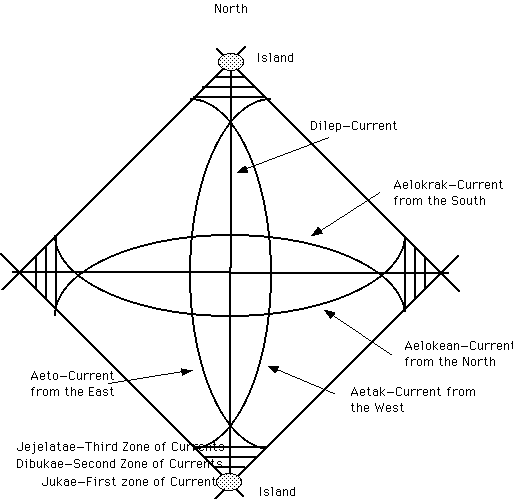
Explanation of a
All three of these waves together are called
Next the hits the
At this point very close attention is given to the waves, for the people in the boat know they are now beginning to approach the new island although it is still very far away. The boat proceeds north and hits the place where again the
*) The bulk of this section is courtesy of:
Curtis, Carol (1986) Handcrafts of the Marshall Islands. Typescript. Majuro: Museum of the Marshall Islands.
![]()
| select from the following... | ||||||
| |
||||||
|
Digital Micronesia-An
Electronic
Library & Archive
is provided free of charge
as an advertising-free
information service
for the world community. It is being maintained by Dirk
HR Spennemann, Associate
Professor in Cultural
Heritage Management, Institute of Land, Water and Society and School
of Environmental & Information Sciences, Charles
Sturt University,
Albury, Australia. The server
space and technical support are provided by Charles
Sturt University as part of its commitment
to regional engagement. Environmental
SciencesInformation
Sciences
|
||||||