
|
Taroa, Maloelap Atoll |
![]()
Left: A 150mm howitzer on the beach of Taroa![]()
After the capitulation of the German Empire in 1918, the newly formed League of Nations gave all former German possessions north of the Equator to the Japanese Empire for administration. The Japanese established a centralised district administration in Jaluit. The internal affairs of Maloelap Atoll were left to be handled by a local atoll headman set up by the Japanese.
In the late 1930s Japan began to develop a military infrastructure and fortifications in its Marshall Islands possessions - contrary to the Covenant of the League of Nations.

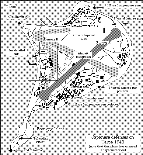
Map of the Taroa Air Base. See further below for a detailed map of the central village area (rectangle).
The Japanese constructed an airfield with two runways (4800' + 4100'), two hangars and a service apron. At the beginning of the US bombing a third runway had been begun. By end of 1943 there was a total of 380 buildings on Taroa (with >=490,000 square feet floor space), 80 of which had a floor space greater than 50 feet square. It had several power stations, a command centre, an air operations centre, fuel farms (35,000 gals.), a pier for larger ships, several ammunition bunkers, a large barracks area, and an extensive workshop area. The garrison had an extensive road network serviced by over 70 vehicles.
![]()
Left: A Mitsubishi A6M fighter plane.![]()
There were two radar sets (range 50 miles) on island, giving the air wing some 10 minutes warning. During the war two squadrons of planes were stationed here many of which were destroyed on the ground. A large number of plane wrecks, mainly Zero-fighters (Mitsubishi A6M) and Betty-bombers (Mitsubishi G3M) are scattered about on the island.
The perimeter of the island, especially the ocean side, bristled with guns, which were a mixture of British and Japanese manufacture: 8 6" and 2 12cm coastal defense guns, 4 6" howitzers, 5 127mm dual purpose guns, 69 anti-aircraft guns and an assortment of small guns.
Between Feb. 1942 and Aug. 1945, US aircraft dropped 3543t of bombs and US ships shot 453t of shells onto Taroa. While the first attacks were carrier-based and irregular, daily attacks were started after Majuro and Kwajalein had fallen to the U.S. At the same time, all supply lines to Taroa were cut off, and the Japanese garrison was left to starve. Of the originally 3097 strong Japanese garrison (1772 Navy, 368 Army, 957 civilians) only 1041 (34%) survived. Several Marshallese were also killed. The survivor rate for Maloelap is the worst of all bases in the Marshalls. Death occurred from air raids, diseases, accidents, and suicides, but mainly from starvation.

![]()
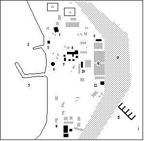
Administrative centre: 1-the plane parks here; 2-small boat ramp; 3-main wharf;
4-concrete-covered fuel tanks; 5-small pillbox; 6-command building; 7-water
tanks; 8-"German"-style pillbox; 9&10-airraid shelters; 11-air operations
building; 12-hangars; 13-service apron for planes; 14-main power station;
15-aircraft revetments with remains of Japanese zeroes.![]()
Today these areas are largely overgrown with scrub and low but very dense bush. To some extent this impedes a visitor's progress and it can be tiring for children. Thus it is recommended that you follow a guide. An island-style lunch will be provided at the school house between noon and 1pm. Thus the day falls naturally into two major tour options. We recommend that you make use of tour 1. More intrepid visitors should use tours 2 or 3 in the afternoon which will give you more detail. If you intend to go on extended tours it is advisable to bring along some water as it may get hot.
![]()
Left: A bombed-out water tank (tilted) with the main administration building in the background.![]()
Chamisso, A. von, 1986, A yoyage around the world with the Romanzov exloring expedition in the years 1815-1818 in the Brig Rurick, Captain Otto von Kotzebue. Honolulu: University of Hawaii Press.
Denfeld, D.C., 1981, Japanese fortifications and other military structures in the Central PacificSaipan: Historic Preservation Office
Hezel, F.X., 1983, The First Taint of Civilisation. Honolulu: University of Hawaii Press.
Peattie, M., 1989, Nan'yo: The rise and fall of the Japanese in Micronesia, 1885-1945. Honolulu: University of Hawaii Press.
If you have questions regarding the history or the heritage on Taroa, feel free
to contact the Alele Museum & Library in Uliga on Majuro, where copies of
books on Taroa are held; or the Historic Preservation Office, Ministry of
Interior and Outer Islands Affairs, Majuor Atoll, Repiublic of the Marshall Islands.

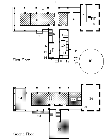
Command and radio building. 1-main entrance; 2-open verandah; 3-radio room; 4-unknown function; 5-generator room; 6-generators; 7-side entrance; 8-staircase with wall cupboard underneath; 9-food storage; 10-kitchen; 11-changing room of bath; 12-bath tub; 13-water heater; 14-urinals; 15-toilets; 16-washroom; 17-bell tower; 18-water tank; 19&25-balcony; 20-staircase to the roof; 21&22-radio rooms; 23-bomb-proof door; 24-transmitter room.
| select from the following... | ||||||
|
|
||||||
|
Digital Micronesia-An
Electronic
Library & Archive
is provided free of charge
as an advertising-free
information service
for the world community. It is being maintained by Dirk
HR Spennemann, Associate
Professor in Cultural
Heritage Management,Institute of Land, Water and Society and
School
of Environmental & Information Sciences, Charles
Sturt University,
Albury, Australia. The server
space and technical support are provided by Charles
Sturt University as part of its commitment
to regional engagement. Environmental
SciencesInformation
Sciences
|
||||||